'Yaas to intensify by late Tue night'

KOLKATA: Very severe cyclonic storm 'Yaas' is likely to make landfall near Dhamra Port in Odisha's Bhadrak district on early Wednesday morning, said Regional Meteorological Centre (RMC) in Alipore.
"Yaas will intensify into a very severe cyclonic storm by late Tuesday night and is likely to hit any region between Dhamra Port and Balasore on the Odisha coast during Tuesday morning. It will cause maximum damages mainly to two districts — East Midnapore and South 24-Parganas. The wind speed will be around 185 km per hour at the time of landfall in Odisha," MeT office said.
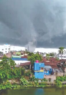
Various South Bengal districts, including Kolkata, received intermittent rainfall on Tuesday. In another development, a low pressure was created over Hooghly River in Bandel on Tuesday evening and triggered a cyclonic circulation. It caused damage to several houses in Bandel in Hooghly and Halishar in North 24-Parganas. People in the region panicked. Two people died in Pandua after being electrocuted.
The sea in Bengal and Odisha coasts turned turbulent from Tuesday morning. The cyclone was situated 290 km south-south east of Digha in Bengal and 290 km south of Balasore in Odisha till Tuesday evening.
Sanjib Bandyopadhyay, head of the RMC Alipore, said: "The wind speed will be around 90-120 kmph in East Midnapore gusting upto 145 kmph from Wednesday morning. In the adjoining districts of Jhargram and West Midnapore, the wind will be measured at 80-90 kmph gusting upto 110 kmph. At South 24-Parganas, the wind speed will be 80-90 kmph gusting upto 100 kmph. North 24-Parganas may witness a wind speed of around 70-80 kmph, gusting upto 90 kmph. The wind speed in Kolkata may be recorded at 65-75 kmph, gusting upto 85 kmph."
"Isolated places of West Midnapore, Howrah, Hooghly, North 24-Parganas and Kolkata will receive heavy rainfall on Wednesday while East Midnapore, Jhargram, South 24-Parganas will witness a very heavy rainfall. Intensity of rainfall will be much higher on Wednesday," Bandyopdhyay stated further.
The cyclone would lose strength after landfall and then head towards neighbouring Jharkhand. However, some experts said unlike Super cyclone Amphan, Yaas would stay in the region for longer as it had been moving slowly. "Since the storm has formed closer to land, it won't get time to travel much longer and may not be that powerful. Super cyclone Amphan had travelled a much longer distance before hitting land and moved through the coast very fast," a weather expert said.
Various state government departments, including the Food and Supply department and Health department opened round the clock control rooms. Officials would perform their duties in two shifts in both the departments.
State power minister Aroop Biswas said adequate arrangements had been made to combat the aftermath. About 1,205 teams of WBSEDCL have been working across 17 districts for carrying out restoration work. At least 100 teams have been kept reserved for any emergency.


