The way out: A fresh outline
Reconstitution of the heavily populated and fast-growing Delhi as two UTs — NCTD under LG and NCR under CM — can both ensure the strategic control of the Centre over the national capital and an effective localised governance

In the previous article, we discussed that even though a legislative assembly was instituted in Delhi, governance remained a matter of controversy between the LG and council of ministers. Is there a way out of this impasse? One must reckon with the fact that Delhi is one of the fastest growing regions in the country, and is already ahead of many states (Uttarakhand, Himachal, Tripura, Meghalaya, Manipur, Nagaland, Goa, Arunachal, and Sikkim) and the highest among the eight UTs in terms of population. By 2028, it will equal, or exceed the population of Haryana and Chhattisgarh. Also, if one went by the population criterion, Delhi would have a substantial rise in the number of its MPs (from seven to 12) after the next round of delimitation.
The best option is to reconstitute Delhi as two UTs – NCTD and NCR. The NCTD should be confined to NDMC, Delhi Cantonment and the aero city — which are geographically contiguous and compact — and placed under a Chief Commissioner or LG reporting to the MHA. The most important buildings and establishments of the Government of India, including the Rashtrapati Bhawan, the new Parliament complex, all the ministries, departments, state Bhawans, diplomatic missions as well as the defence establishments and the airport will come within this area. Except for Red Fort where the PM unfurls the flag on the Independence Day, every other venue, including the National War Memorial and Rajghat are in New Delhi. If required, the jurisdiction of the NCTD may be extended to cover Red Fort as well – and it is just a few kilometres from the Bahadur Shah Zafar Marg which is in New Delhi.
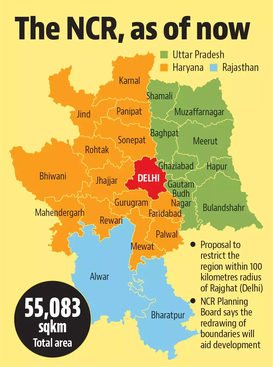
The rest of Delhi — with the addition of districts and tehsils of UP, Haryana and Rajasthan which are part of the NCR — should be constituted as the UT of NCR but with a higher degree of devolution of political authority. This region too should belong to the entire nation, and every Indian should have a right to study, work and settle in the region. This NCR will be the magnet of entrepreneurial growth as well as the hub for education, media, commerce, green manufacturing, MSME and the services sector. This UT should have a legislative assembly and an effective CM with 'almost' the same powers as a regular state. The NCR was defined by the NCR Act in 1985, and at the time of its inception, it included the whole of Delhi — the districts of Gurgaon, Faridabad and Sonipat, Rohtak (including Jhajjar tehsil) and the Rewari tehsil then in Mahendragarh district, in Haryana; Bulandshahr, Muzaffarnagar, Meerut (then including Baghpat tehsil), and Ghaziabad (including Hapur tehsil) in UP; and some parts of Alwar in Rajasthan. This NCR covered an area of 34,144 square kilometres. Gautam Budh Nagar district was created in 1997 out of the existing NCR districts of Ghaziabad and Bulandshahr. The city of Noida was the location of the new district's headquarters. Also, in 1997, Baghpat district was created from Baghpat tehsil of Meerut District.
In July 2013, the NCR was expanded to include three more districts — Bhiwani, and Mahendragarh in the state of Haryana, as well as Bharatpur in the state of Rajasthan. This brought the number of districts outside of Delhi NCT to 19, and the total NCR area was now 45,887 sq km. In 2015, the Government of India approved the inclusion of three more districts in NCR — Jind, Panipat and Karnal — in the state of Haryana and Muzaffarnagar in Uttar Pradesh, thereby extending the total area to 50,566 km. Shamli district of UP was added to the NCR in December 2017. In 2018, the government of Uttar Pradesh formally proposed the extension of the NCR to cover the districts Aligarh, Bijnor, Hathras, Mathura and Agra. Punjab pitched for the inclusion of Patiala and Mohali in the NCR. It was as if inclusion in NCR was a panacea for all the infrastructure and development issues.
While UP, Rajasthan and Punjab were keen on expanding the circle of NCR, it caused a major concern in Haryana, for almost the entire state was coming under its ambit. It was felt that after a few decades, the very existence of the state may come under cloud. Moreover, the NCR itself was becoming quite unwieldy, and the criterion for inclusion was rather 'subjective'. A course correction was done in 2021, restricting NCR to a hundred-kilometre radius from the Rajghat, as against the earlier criterion of including areas up to 175 km. This would also reduce the size of the NCR to a manageable 37.115 square kilometres.
This is certainly not an easy task, and there will be tremendous opposition from the constituent states from which districts will be cut off for the NCR. As such, this must be part of the larger exercise of reorganization of states which ought to be done before the next round of delimitation and must address the issue of great asymmetry among the states. However, whenever this exercise is undertaken, there will be a strong case for a new UT of NCR, besides of course a compact UT for NCTD.
Views expressed are personal


