Built on the glorious past
After changing many hands through the long passage of history, NCR in its new form remains a bustling centre of socio-economic and political life

The real challenge in writing this column is not the dearth of information, sources or reference materials. On the contrary, it is about how to sift from the plethora of information about a city with a living tradition from the second millennium century BCE! The number of books, scholarly and popular articles, social media posts and archival material is so vast that it can take a lifetime to document the transition from Indraprastha, the legendary capital of the Pandavas in the Mahabharata, to the present day. Indraprastha was followed by Srinivaspuri in the Mauryan period, the Tomar settlement of Surajkund and Lalkot in the 9th century. Quila Rai Pithora was built by Prithvi Raj Chauhan in 1180 CE but was then redeveloped as the Qutub Minar complex by the Mamluk (slave dynasty) from 1200 to 1290 CE. Siri fort which was established by Alaudin Khalji in 1300 CE was followed by Tughlaqabad, Jahanpanah and Firozabad by the Tughluqs from 1320 to 1354. Between 1538 and 1545, Hamayun developed Dinapanah and Feroze Shah Suri built Shergarh, both in the vicinity of the site of Indraprastha (Purana Quila area). When the Mughal Empire was at its zenith (1638-1649), Shahjahan built Shahjahanabad along with the Chandini Chowk, Jama Masjid, and Lal Quila where the Mughals lived till the fall of their Empire in 1857.
As this article is part of the series on the mapping of Indian states, we will take 1911 as the reference point, for this was the year when King George V announced Delhi as the new capital of India on the occasion of the Coronation Durbar. Delhi had been the national capital of India till 1858 as the last Moghul Bahadur Shah Zafar was the de jure head, even though from 1803, the British East Indian Company had taken effective control of the city after the second Maratha–Anglo War. Delhi came under the direct control of the British and was made part of British Punjab. In 1912, Delhi became a Chief Commissioner's province with William Malcolm Hailey (on whom the Hailey road is named) as the first incumbent.
The name New Delhi was given in 1927, and the formal inauguration took place on February 13, 1931. Also called Lutyens' Delhi after the architect who designed the Raisina Hills and the surrounding buildings, it was officially declared the capital of the Union of India after the country gained Independence. However, it continued to be a Chief Commissioner's province and its status (along with that of Ajmer Merwara and Coorg) came up for discussion in the Constituent Assembly debates where Deshbandhu Gupta and BK Sidhwa raised the issue of popular government in Delhi. The resolution moved by Gupta called for 'suitable constitutional changes' to be brought about in the administrative systems of Chief Commissioner's provinces so as to accord with the changed conditions in the country and to give them their due place in the democratic Constitution of free India'.
The partition of the country marked a major change in the demographic profile of Delhi as thousands of Hindus and Sikh refugees, mainly from West Punjab, fled to Delhi while many Muslim residents migrated to Pakistan. The tragedy of partition has been covered extensively in literary works in English, Hindi, Punjabi and Urdu, but it did transform Delhi into a 'migrant city'. It spurred unparalleled economic growth not just in Delhi, but also in the surrounding towns like Sonepat, Panipat, Gurgaon, Faridabad and Ghaziabad. In fact, the annual average exponential growth rate of the population of Delhi was highest during the decade of 1941-51 and had been double that of the national average. Even as the birth rate is showing a decline, the population is rising because of immigration from UP, Haryana, Bihar, Northeast, Punjab, MP and Chhattisgarh. The rural area of Delhi is also declining sharply, and over the next decade, there will hardly be any rural population left.
With the promulgation of the Constitution of India, Delhi became a Part C state. The first Delhi legislative assembly was constituted in March 1952, and Chaudhary Brahm Singh took over as the first CM, albeit with limited powers, and with an advisory role to the then Chief Commissioner. However, as per the recommendations of the States Reorganization Commission which came into effect from November 1956, Delhi became a Union territory under the direct administration of the Government of India (MHA). The legislative assembly was dissolved and the Council of Ministers abolished simultaneously. The Delhi Municipal Act of 1957 led to the formation of a municipal corporation, but with the Delhi Administration Act of 1966, a Metropolitan Council was created and the administration was brought under a Lt Governor.
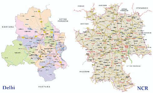
Finally by the 69th Constitutional Amendment Act, 1991, the Assembly and the Council of Ministers was restored, and the official name was National Capital Territory of Delhi. However, the LG continues to exercise overriding powers, especially in matters concerning land, law and order and appointments of senior officials. Delhi is also at the centre of the National Capital Region which was created to take care of the ever-expanding urban conglomeration and now includes a total of 24 districts in three neighbouring states of Haryana, Uttar Pradesh and Rajasthan along with the whole of the National Capital Territory. It is also one the fastest growing urban conglomeration globally, with the largest metropolitan police and an economic growth magnet where the population is growing largely on account of migration from across the country.
The writer is the Director of LBSNAA and Honorary Curator, Valley of Words: Literature and Arts Festival, Dehradun. Views expressed are personal


